Conservation monitoring: Using innovation and collaboration to drive coastal resilience
August 25, 2021
August 25, 2021
How our multidisciplinary team developed a sustainable solution to protect shellfish populations along the West Coast
Ever wonder where you can find a beautiful coastline with northwest waves and gorgeous oceanside sunsets in the US?
Near the town of Westport, Washington, the coastal region comprised of Grays Harbor and the Willapa Bay estuaries (Twin Harbors) provides natural respite for residents and visitors from around the world. From surfing and camping to fishing and relaxation, Twin Harbors has a lot to offer for people who want to appreciate the great outdoors—particularly after this past year.
Twin Harbors is also one of the most fruitful shellfish producers in the US. In fact, the region makes up around a quarter of the entire US shellfish industry! Local, state, and federal governments all rely on this shellfish production as it supplies jobs and boosts the economy on all levels.
But since the 1990s, the coastal region has been deteriorating, and it’s negatively impacting the shellfish. How? Changing weather conditions, dredging for navigation, and an increase in burrowing shrimp are disrupting the seafloor by bringing up sediment and muddying the waters—so to speak. This has resulted in shellfish populations being buried, suffocated, and lost.

Local fishing boat in Grays Harbor, Washington.
So, we partnered with the Grays Harbor Conservation District to help the Pacific Coast Shellfish Growers Association (PCSGA) find a solution to this sedimental challenge. How? We brought in a diverse suite of experts to develop complex coastal models that can estimate and predict sediment deposition as it impacts the shellfish industry over time.
Our goal? To revitalize the local shellfish industry while promoting biodiversity and creating healthy ecosystems in the process. As we are in the UN’s Decade on Ecosystem Restoration, what an ideal time to investigate this project and how it might impact other coastal restoration efforts.
Before we could develop our coastal models, we had to determine what information to input. This meant a comprehensive effort to collect all available information. We achieved this by breaking data collection down into three pillars: Online data research, stakeholder surveys, and Interferometric Synthetic Aperture Radar (InSAR) data.
Our online data research helped us understand the characteristics of wind, waves, tide, discharge, and bed sediments within the region. Our engagement experts also surveyed stakeholders and incorporated any relevant information into the study. This was to help us to incorporate local knowledge on shellfish, shrimp, marsh, and sediment in the region to supplement the online data.
After all, the Decade on Ecosystem Restoration is now. So, let’s work to revitalize our ecosystems for shellfish and any other species in need of protection.
We then brought in our remote sensing team to gather even more data with InSAR. InSAR is a revolutionary tool that uses satellite imagery to monitor ground deformation from space with millimetre accuracy and precision. Our team amalgamated 31 InSAR images over a 5-year period (2015-2019) when tidal flats were exposed during low tide to determine the rate and significance of the erosion and sedimentation. This provided us with a much better understanding of not only the issue but how we could solve it.
Thanks to our multidisciplinary team of experts—project managers, engagement experts, remote sensing specialists—we were able to gather all this data and determine a path forward.

InSAR is a revolutionary tool that uses satellite imagery to monitor ground deformation from space with millimetre accuracy and precision.
Once we had all the information we needed, our coastal engineering team was able to develop numerical models of the Twin Harbors region. These models gave us an in-depth analysis of where the most active sediment is and why it’s happening. It would also help us identify alternative, stable areas of sediment where shellfish can grow safely.
First, we created a hydrodynamic model to simulate tide, current, and storm surge from wind in the region. This was achieved by developing and calibrating a Delft3D Flow FM and WAVE model—a modelling tool used to determine the dynamics within Twin Harbors, as well as how the sediment responds to those dynamics. This showed us that sediment shifts south in the summer and north during the winter.
We also developed a morphological model to further understand how the sea floor has changed over time. These simulations give us a long-term picture of health of the coast—what it was, what it is, what it will be. It also gave us more insight into annual changes and seasonal variations. Again, these models showed us that strong northern winds in the winter are accelerating erosion and sedimentation.
Now that we backed up our data collection with richly calibrated modelling, we could move onto finding a practical solution to protect shellfish populations.
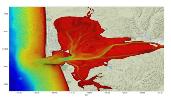
Our Delft3D-WAVE Model is a modelling tool used to determine the dynamics within Twin Harbors, as well as how the sediment responds to those dynamics.
Our findings from our research and modelling tools told us a few key things about sedimentation and erosion dynamics. While some sedimentation does occur naturally over shellfish growing beds, excess sedimentation is enhanced by the strong winter winds and raging waves. Sediment from a nearby dredging disposal site also seems to be adding to the problem.
To mitigate the impacts of sedimentation on the growing beds, we needed to accomplish two primary objectives. The first was attenuate waves over the growing beds. The second was to reduce morphological changes to the growing bed sites over time. Achieving these two objectives would lead to less sedimentation and safer shellfish populations.
We also proposed an alternative site for potential future use. Our sediment transport model showed us the path of sediment through the Twin Harbors coastal region. And we found that by moving the shellfish farm slightly north, we could get it out of the primary pathway that sediment takes through the region.
Ultimately, the PCSGA could understand why this sedimentation was happening, where and when it is taking place, and what they could do to mitigate it.

We determined a thoughtful solution to protect the shellfish and their ecosystem, promoting biodiversity in the process.
The way we see it, this project was a success on all fronts. We established why the Twin Harbors region was experiencing excess sedimentation. We determined a thoughtful solution to protect the shellfish and their ecosystem, promoting biodiversity in the process. We helped to revitalize the shellfish industry in the Twin Harbors region and drive economic benefits for the communities that live there. And we did all this while demonstrating that multidisciplinary teamwork—and innovative technology—can unlock the potential of any project.
We look forward to seeing these ideas and innovative solutions in future coastal resilience projects. After all, the Decade of Ecosystem Restoration is now. So, let’s work to revitalize our ecosystems for shellfish and any other species in need of protection.
